It is necessary to open up the ground because the land cover is growing, hiding the artifacts. The main reasons for this increase are:
- accumulation of waste as a result of human activity;
- transport of soil particles by wind;
- natural accumulation of organic matter in the soil (for example, as a result of rotting leaves);
- deposition of cosmic dust.
Excavation permit
Excavations by their nature lead to the destruction of the cultural layer. Unlike laboratory experiments, the excavation process is unique. Therefore, in many states, special permission is required for excavations.
Excavations without permission are an administrative offense in the Russian Federation.
Purpose of excavation
The purpose of the excavations is to study the archaeological monument and reconstruct its role in historical process. It is preferable to completely open the cultural layer to its entire depth, regardless of the interests of a particular archaeologist. However, the excavation process is very labor-intensive, so often only part of the monument is opened; many excavations last for years and decades.
A special type of excavation is the so-called security excavations which, in accordance with legal requirements, are carried out before the construction of buildings and structures, since otherwise the archaeological monuments located at the construction site may be lost forever.
Archaeological exploration
The study of the excavation site begins with non-destructive methods, including measurements, photography and description.
Sometimes, during the exploration process, “probes” (pits) or trenches are made to measure the thickness and direction of the cultural layer, as well as to search for an object known from written sources. These methods spoil the cultural layer and therefore their use is limited.
Excavation technology
To obtain a holistic picture of life in the settlement, it is preferable to simultaneously open a large continuous area. However, technical limitations (observation of layer cuts, removal of soil) impose restrictions on the size of the excavated area, the so-called excavation.
The excavation surface is leveled and divided into squares (usually 2x2 meters). The opening is carried out in layers (usually 20 centimeters) and squarely using shovels and sometimes knives. If layers are easily traced on a monument, then the opening is carried out by layers, and not by strata. Also, when excavating buildings, archaeologists often find one of the walls and gradually clear the building, following the line of the walls.
Mechanization is used only for removing soil that does not belong to the cultural layer, as well as for large mound embankments. When objects, burials or their traces are discovered, knives, tweezers and brushes are used instead of shovels. To preserve finds from organic substances, they are preserved directly in the excavation site, usually by pouring them with plaster or paraffin. The voids left in the ground from completely destroyed objects are filled with plaster to obtain a cast of the disappeared thing.
The study of the distant past is necessarily accompanied by careful photographic recording of all stages of clearing archaeological remains. On the territory of the Russian Federation, the requirements for the professional knowledge and skills of the researcher are strictly regulated by the “Regulations on the procedure for conducting archaeological field work and drawing up scientific reporting documentation.” The report must certainly contain:
- a complete description of the archaeological heritage site under study and its topographic plan, prepared using geodetic instruments;
- data on the distribution of bulk material on the exposed site with the application of statistical tables (lists) and drawings of things;
- a detailed description of the excavation methodology, as well as each studied burial, all identified objects (funeral funerals, altars, cenotaphs, bedding, bedding, fire pits, etc.) indicating the size, depth, shape, structural details and elements, orientation, leveling marks;
- information about special analyzes performed with the involvement of anthropologists, biologists, geologists, etc.;
- sections of holes and other recesses indicating the features of their filling;
- stratigraphic profiles of edges and walls;
The greatest importance is attached to the quality of the accompanying drawings, which Lately are increasingly being created using modern computer technology. The need for planigraphic observations should also be noted.
see also
Write a review about the article "Excavations"
Notes
Sources
Literature from the Historical Encyclopedia:
- Blavatsky V.D., Ancient field archeology, M., 1967
- Avdusin D. A., Archaeological exploration and excavations M., 1959
- Spitsyn A. A., Archaeological excavations, St. Petersburg, 1910
- Crawford O. G. S., Archeology in the field, L., (1953)
- Leroi-Gourhan A., Les fouilles préhistoriques (Technique et méthodes), P., 1950
- Woolley C. L., Digging up the Past, (2 ed), L., (1954)
- Wheeler R. E. M., Archeology from the Earth, (Harmondsworth, 1956).
Links
- // Jewish Encyclopedia of Brockhaus and Efron. - St. Petersburg. , 1908-1913.
Excerpt describing the Excavations
- Crash it, guys! - he said and he himself grabbed the guns by the wheels and unscrewed the screws.In the smoke, deafened by continuous shots that made him flinch every time, Tushin, without letting go of his nose warmer, ran from one gun to another, now taking aim, now counting the charges, now ordering the change and re-harnessing of dead and wounded horses, and shouted in his weak, thin voice, in a hesitant voice. His face became more and more animated. Only when people were killed or wounded did he wince and, turning away from the dead man, shout angrily at the people, as always, who were slow to raise the wounded man or the body. The soldiers, for the most part handsome fellows (as always in a battery company, two heads taller than their officer and twice as wide as him), all, like children in a difficult situation, looked at their commander, and the expression that was on his face remained unchanged reflected on their faces.
As a result of this terrible hum, noise, need for attention and activity, Tushin did not experience the slightest unpleasant feeling of fear, and the thought that he could be killed or painfully wounded did not occur to him. On the contrary, he became more and more cheerful. It seemed to him that a very long time ago, almost yesterday, there was that minute when he saw the enemy and fired the first shot, and that the patch of field on which he stood was a long-familiar, familiar place to him. Despite the fact that he remembered everything, understood everything, did everything that the best officer in his position could do, he was in a state similar to feverish delirium or the state of a drunken person.
Because of the deafening sounds of their guns from all sides, because of the whistle and blows of the enemy’s shells, because of the sight of the sweaty, flushed servants hurrying around the guns, because of the sight of the blood of people and horses, because of the sight of the enemy’s smoke on the other side (after which everyone once a cannonball flew in and hit the ground, a person, a gun, or a horse), because of the appearance of these objects, his own fantasy world, which was his pleasure at that moment. The enemy cannons in his imagination were not cannons, but pipes, from which an invisible smoker released smoke in rare puffs.
“Look, he puffed again,” Tushin said in a whisper to himself, while a puff of smoke jumped out of the mountain and was blown to the left by the wind in a stripe, “now wait for the ball and send it back.”
-What do you order, your honor? - asked the fireworksman, who stood close to him and heard him muttering something.
“Nothing, a grenade...” he answered.
“Come on, our Matvevna,” he said to himself. Matvevna imagined in his imagination a large, extreme, antique cast cannon. The French appeared to him like ants near their guns. The handsome and drunkard number two of the second gun in his world was his uncle; Tushin looked at him more often than others and rejoiced at his every move. The sound of the gunfire, which either died down or intensified again under the mountain, seemed to him like someone’s breathing. He listened to the fading and flaring up of these sounds.
“Look, I’m breathing again, I’m breathing,” he said to himself.
He himself imagined himself to be of enormous stature, a powerful man who hurled cannonballs at the French with both hands.
- Well, Matvevna, mother, don’t give it away! - he said, moving away from the gun, when an alien, unfamiliar voice was heard above his head:
- Captain Tushin! Captain!
Tushin looked around in fear. It was the staff officer who kicked him out of Grunt. He shouted to him in a breathless voice:
- What, are you crazy? You were ordered to retreat twice, and you...
“Well, why did they give me this?...” Tushin thought to himself, looking at the boss with fear.
“I... nothing...” he said, putting two fingers to the visor. - I…
But the colonel did not say everything he wanted. A cannonball flying close caused him to dive and bend over on his horse. He fell silent and was just about to say something else when another core stopped him. He turned his horse and galloped away.
- Retreat! Everyone retreat! – he shouted from afar. The soldiers laughed. A minute later the adjutant arrived with the same order.
It was Prince Andrei. The first thing he saw, riding out into the space occupied by Tushin’s guns, was an unharnessed horse with a broken leg, neighing near the harnessed horses. Blood flowed from her leg like from a key. Between the limbers lay several dead. One cannonball after another flew over him as he approached, and he felt a nervous shiver run down his spine. But the very thought that he was afraid raised him up again. “I cannot be afraid,” he thought and slowly dismounted from his horse between the guns. He gave the order and did not leave the battery. He decided that he would remove the guns from the position with him and withdraw them. Together with Tushin, walking over the bodies and under terrible fire from the French, he began cleaning up the guns.
“And then the authorities came just now, so they were tearing up,” the fireworksman said to Prince Andrei, “not like your honor.”
Prince Andrei did not say anything to Tushin. They were both so busy that it seemed they didn’t even see each other. When, having put the surviving two of the four guns on the limbers, they moved down the mountain (one broken cannon and the unicorn were left), Prince Andrei drove up to Tushin.
“Well, goodbye,” said Prince Andrei, extending his hand to Tushin.
“Goodbye, my dear,” said Tushin, “dear soul!” “goodbye, my dear,” said Tushin with tears that, for some unknown reason, suddenly appeared in his eyes.
The wind died down, black clouds hung low over the battlefield, merging on the horizon with gunpowder smoke. It was getting dark, and the glow of fires was all the more clearly visible in two places. The cannonade became weaker, but the crackle of guns behind and to the right was heard even more often and closer. As soon as Tushin with his guns, driving around and running over the wounded, came out from under fire and went down into the ravine, he was met by his superiors and adjutants, including a staff officer and Zherkov, who was sent twice and never reached Tushin’s battery. All of them, interrupting one another, gave and passed on orders on how and where to go, and made reproaches and comments to him. Tushin did not give orders and silently, afraid to speak, because at every word he was ready, without knowing why, to cry, he rode behind on his artillery nag. Although the wounded were ordered to be abandoned, many of them trailed behind the troops and asked to be deployed to the guns. The same dashing infantry officer who jumped out of Tushin’s hut before the battle was, with a bullet in his stomach, placed on Matvevna’s carriage. Under the mountain, a pale hussar cadet, supporting the other with one hand, approached Tushin and asked to sit down.
4.1. Archaeological excavations are field archaeological work carried out for the purpose of a comprehensive study, accurate recording and scientific assessment of an archaeological monument with a full description of its topography, stratigraphy, cultural layer, structures, archaeological material, dating, etc.
4.2. Based on the generally accepted principles of preference for the physical preservation of objects of archaeological heritage as evidence historical eras and civilizations enshrined in federal legislation and contained in international treaties to which the Russian Federation is a party, archaeological monuments that are under threat of destruction during construction and economic work or the influence of other anthropogenic and natural factors are subject to excavation, first of all.
Conducting archaeological excavations at archaeological heritage sites that are not in danger of destruction is possible if the application for an Open Sheet contains a reasoned scientific justification for the need to conduct research to solve fundamental scientific problems.
4.3. Carrying out stationary excavations of an archaeological monument must be preceded by a stage of detailed examination of both the archaeological monument itself and the surrounding area, familiarization with historical, archival and museum materials relating to these objects, as well as the mandatory preparation of an instrumental topographic plan on a scale of at least 1:1000 and a comprehensive photographic recording of an archaeological monument.
4.4. The choice of location for excavation at an archaeological site when conducting field work on the Open Sheet according to Form No. 1 is determined by the scientific objectives of the research. At the same time, the interests of ensuring the safety of the archaeological monument should be taken into account and preference should be given to excavating those sections of it that are in to the greatest extent is threatened with damage or destruction as a result of natural processes or anthropogenic impact.
4.5. Excavations of settlements and ground burial grounds should be carried out in areas that provide the most complete characterization of stratigraphy, structures and other archaeological objects.
Excavations of archaeological monuments using pits or trenches are strictly prohibited.
It is prohibited to lay small excavations over individual objects - residential depressions, residential areas, graves, etc. All of them must be included within the boundaries of the general excavation, which also includes the space between objects.
Indestructible archaeological sites should not be completely excavated. When excavating these archaeological monuments, it is necessary to reserve part of their area for future research, based on the fact that improving field research methods in the future will provide an opportunity for a more complete and comprehensive study of them.
4.6. One should strive to establish a minimum number of excavations at one archaeological site.
It is prohibited to leave small areas or strips of unexposed cultural layer between excavations.
4.7. If it is necessary to lay several excavations in different parts of an archaeological site, they should be divided into a single coordination grid fixed on the ground to ensure the joining of excavations and geophysical and other research data.
It is recommended to apply such a grid over the entire monument at the beginning of work. It is necessary to coordinate the elevation marks at all excavations, for which a single constant must be installed on the monument rapper. The location of the benchmark must be recorded on the plan of the monument. It is desirable to link the benchmark to the Baltic system of elevations.
4.8. One of the priorities of archaeological research is an integrated approach to the study of archaeological monuments and the involvement of natural science specialists (anthropologists, geophysicists, soil scientists, geologists, geomorphologists, paleobotanists, etc.) to record natural conditions, which contain archaeological objects, study of paleoenvironment and analysis of paleoecological materials. During the work, it is advisable to carry out the most complete selection of paleoecological materials and other samples for their study in laboratory conditions.
4.9. The study of the cultural layer of settlements, ground burial grounds and burials is carried out only with hand tools.
The use of earth-moving machines and mechanisms for these purposes is strictly prohibited. Such machines can be used exclusively for auxiliary work (transportation of waste soil, removal of a sterile or man-made layer covering a monument, etc.). During underwater excavations, the use of soil-washing equipment is allowed.
4.10. When exploring mounds, the embankment should be dismantled with hand tools.
The use of earth-moving machines is allowed only when excavating mounds of certain types (the paleometal era - the Middle Ages of the steppe and forest-steppe zones). Removal of soil by mechanisms should be carried out in thin (no more than 10 cm) layers with the organization of continuous careful observation of the uncovered area until the first signs of burials, burial structures, pits, funeral feasts, etc. appear, after which dismantling should be done manually.
4.11. Excavation of mounds is carried out only with the removal of the entire embankment and exploration of the entire space located under it, as well as the nearest territory where ditches, powders, funeral feasts, remains of ancient arable land and the like can be found.
The study of burial mounds with poorly defined, strongly blurred or overlapping mounds must be carried out in a continuous area, as well as the study of ground burial grounds, with a grid of squares and one or more edges (depending on the area of the excavation) in the most pronounced areas in the relief.
4.12. An excavation at ancient settlements of all types (sites, settlements, ancient settlements) must be divided into squares, the sizes of which, depending on the type of monument, are: 1x1 m, 2x2 m and 5x5 m. The grid of squares at the excavation site must be inscribed in the general coordinate grid of the monument.
Excavations of ancient settlements of all types are carried out along stratigraphic layers or strata, the thickness of which depends on the type of monument, but should not exceed 20 cm.
It is preferable to study stratified monuments in layers. It is necessary to carefully identify all the features inherent in the cultural layer and the given settlement as a whole.
The remains of all buildings, fire pits, hearths, pits, soil spots, and other objects, as well as the location of finds in coordination with the uncovered structures must be plotted on layer-by-layer or stratum plans. The depths of detected objects and finds must be recorded using a level or theodolite.
When dismantling a cultural layer with a high concentration of small artifacts, it is advisable to wash or sift the cultural layer through fine-mesh metal mesh.
4.13. The use of a metal detector is possible only in areas directly investigated by excavations, as well as for additional regular inspection of dumps.
All finds discovered using a metal detector (including finds from dumps), as well as objects obtained as a result of washing the cultural layer, must be included in the field inventory and provided with appropriate explanations of their origin.
4.14. When excavating multi-layered archaeological monuments, successive deepening into the underlying layers is permissible only after a detailed study of the upper layers and their exhaustive recording throughout the entire excavation area.
4.15. Cultural deposits must be examined in full, unless this is prevented by construction and architectural remains of primary importance discovered in excavations, the preservation of which seems necessary.
4.16. When excavating archaeological monuments with construction and architectural remains, it is necessary to take measures to ensure their safety until they are fully identified and comprehensively recorded. In the case of permanent excavations at one archaeological site leaving the discovered architectural remains in open form measures must be taken to protect and conserve them.
4.17. When conducting security excavations, the researcher is obliged to provide for study in in full the entire site of an archaeological monument within the boundaries of a permanent or temporary land allotment where excavation work or movement of equipment can damage or destroy the archaeological monument.
A selective study of part of an archaeological monument that falls within the boundaries of the land allocation is unacceptable. If necessary, for a complete study of an archaeological site, the researcher can make an extension to the excavation site that goes beyond the boundaries of the construction and excavation site.
4.18. When examining mound embankments, the following must be ensured: identification and recording of all objects located in the embankment (inlet burials, funeral feasts, individual finds, etc.), design features and composition of the embankment itself, the level of buried soil, the presence of bedding, crepides or other structures inside the embankment, under her or around her. All depth measurements should be taken from the zero mark (benchmark), located at the highest point of the embankment. Before demolishing the edge on which the benchmark is located, remote benchmarks are installed outside the excavation, having precise references to the main benchmark; in the future, all depth measurements are made from remote benchmarks.
In addition to burials, all layers and objects are documented on the plans of excavated mounds.
When excavating completely or partially robbed burials, graphic documentation should record the locations and depths of all finds, including those that were moved, since this data is important for reconstructing the original burial complex.
4.19. To conduct and record stratigraphic observations, edges must be left inside large excavations.
When excavating mounds using technology, one or several parallel (in the direction of movement of the mechanisms) edges are left, depending on the size and structure of the mound embankment.
When excavating mounds, two mutually perpendicular edges are left by hand.
When excavating large mounds (over 20 m in diameter), it is necessary to leave at least two or three edges with mandatory recording of all their profiles.
The edges must be disassembled after their drawing and photographic fixation, and the materials obtained during their disassembly are recorded on the corresponding plans.
4.20. In the process of excavating archaeological monuments of all types, it is necessary to level the modern surface (excavation site, mound), profiles, continental surface and all objects (structures, floor levels, layers, hearths, etc., burials, remains of funeral feasts, etc.), as well as finds from a single zero reference point for each monument.
4.21. During the work, a field diary should be kept in which detailed text descriptions of the exposed cultural strata, ancient structures and burial complexes are recorded.
Diary data serves as the basis for writing a scientific report.
4.22. All finds, building materials, osteological, paleobotanical and other remains obtained during excavations are recorded in a field diary, indicated on drawings, and the most revealing ones are photographed.
4.23. The results of excavation work are recorded with drawings and photographic documentation.
Drawings (plans and sections of excavations, stratigraphic profiles, plans and profiles of mounds, plans and sections of burials, etc.) must be made directly at the work site and reproduce as accurately as possible all the details, including such as: the relative position of layers and structures and their relationship to elevations, composition, structure and color of layers, the presence of soil, ash, coal and other stains, distribution of finds, conditions and depth of their occurrence, position of the skeleton and things in the grave, etc.
Plans, sections and profiles of excavations are carried out on a single scale of at least 1:20. Mound plans – no less than 1:50. Plans and sections of burials are on a scale of at least 1:10. When identifying clusters of small items, areas with dense distribution of grave goods and treasures, it is advisable to sketch them on a 1:1 scale. The plans must reflect all the details recorded in the profile. The actual depth of the excavation should be recorded on the section (in the profile).
4.24. It is mandatory to photograph the entire excavation process, starting with the general view of the archaeological monument and its section chosen for study, excavation at different levels of layer removal, as well as all the objects being uncovered: burials, structures and their details, stratigraphic profiles, etc.
Photographic recording must be done using a scale rod.
4.25. Finds collected during excavations should be taken for museum storage and further scientific processing.
In this case, it is advisable to include in the collection the widest possible range of things, including fragmented items and items of unclear purpose.
4.26. Materials entering the collection must be included in the field inventory and provided with labels indicating the year of research and the exact place of origin of each item or fragment: monument, excavation, site, layer or layer, square, pit (No.), burial (No.), dugout ( No.), number of the find, its leveling mark or other detection conditions. The researcher must ensure proper packaging, transportation and storage of collections before they are transferred to the state part of the museum collection of the Russian Federation.
This is the opening of a layer of earth in order to study monuments former places settlements. Unfortunately, this process leads to partial destruction of the cultural soil layer. Unlike laboratory experiments, it is not possible to re-archaeologically excavate a site. In order to open the ground, many states require a special permit. In Russia (and before that in the RSFSR), “open sheets” - the so-called documented consent - are drawn up at the Institute of Archeology of the Academy of Sciences. Carrying out this type of work on the territory of the Russian Federation in the absence the specified document is an administrative offense.
Basis for soil excavation
Land cover tends to increase in mass over time, resulting in the gradual hiding of artifacts. It is for the purpose of their detection that a layer of earth is opened. An increase in soil thickness can occur for several reasons:

Tasks
The main goal pursued by scientists when carrying out archaeological excavations is to study an ancient monument and restore its significance. For a comprehensive, comprehensive study, it is most preferable when it is completely opened to its full depth. At the same time, even the interests of a particular archaeologist are not taken into account. However, as a rule, only partial opening of the monument is carried out due to the high labor intensity of the process. Some archaeological excavations, depending on their complexity, can last for years or even decades. Work can be carried out not only for the purpose of researching historical monuments. In addition to archaeological excavations, there is another type of excavation called “security”. In accordance with the legislation, in the Russian Federation they must be carried out before the construction of buildings and various structures. Because otherwise, it is possible that the ancient monuments at the construction site will be lost forever.

Progress of the study
First of all, the study of a historical object begins with non-destructive methods such as photography, measurement and description. If it becomes necessary to measure the direction and thickness of the cultural layer, sounding is done, trenches or pits are dug. These tools also allow you to search for an object whose location is known only from written sources. However, the use of such methods is of limited application, since they significantly spoil the cultural layer, which is also of historical interest.
Earth opening technology
All stages of research and clearing of historical sites are necessarily accompanied by photographic recording. Conducting archaeological excavations on the territory of the Russian Federation is accompanied by compliance with strict requirements. They are approved in the corresponding “Regulations”. The document focuses on the need to produce high-quality drawings. Recently, they are increasingly issued in electronic form using new computer technologies.

Archaeological excavations in Russia
Not long ago, Russian archaeologists published a list of the most important discoveries of 2010. The most significant events during this period were the discovery of a treasure in the city of Torzhok and archaeological excavations in Jericho. In addition, the age of Yaroslavl was confirmed. Under the leadership of the Institute of Archeology of the Russian Academy of Sciences, dozens of scientific expeditions are equipped every year. Their research extends throughout the European part of the Russian Federation, in some parts of the Asian region of the country and even abroad, for example in Mesopotamia, Central Asia and the Spitsbergen archipelago. According to the director of the institute, Nikolai Makarov, at one of the press conferences, during 2010 the Institute of Archeology of the Russian Academy of Sciences conducted a total of 36 expeditions. Moreover, only half of them were carried out on the territory of Russia, and the rest - abroad. It also became known that approximately 50% of funding comes from the state budget, revenues of the Russian Academy of Sciences and such scientific institutions, as "Russian Fund basic research" and While the rest of the resources intended for carrying out work related to the preservation of archaeological heritage monuments are allocated by investor-developers.

Research of Phanagoria
According to N. Makarov, in 2010 there was also a significant shift in the study of monuments of ancient times. This is especially true of Phanagoria - the largest ancient city found on the territory of Russia, and the second capital of the Bosporan kingdom. During this time, scientists studied the buildings of the acropolis, and found a large building, the age of which dates back to the middle of the 4th century BC. e. All archaeological excavations in Phanagoria are conducted under the leadership of Doctor of Historical Sciences Vladimir Kuznetsov. It was he who identified the found building as one in which state meetings had previously been held. A notable feature of this building is the hearth, in which a fire was previously kept burning every day. It was believed that as long as its flame shines, public life of the ancient city will never cease.
Research in Sochi
Another significant event of 2010 was the excavations in the capital of the 2014 Olympics. A group of scientists, headed by Vladimir Sedov, Doctor of Art History and leading researcher at the Institute of Archeology, conducted research near the construction site of the Russian Railways terminal near the village of Veseloye. Here the remains of a Byzantine temple from the 9th-11th centuries were subsequently discovered.

Excavations in the village of Krutik
This is a trade and craft settlement of the 10th century, located in the forests of Belozorye, Vologda region. Archaeological excavations in this area are headed by Sergei Zakharov, candidate of historical sciences. In 2010, 44 coins minted in the countries of the caliphate and the Middle East were found here. Merchants used them to pay for furs, which were especially valued in the Arab East.
Archaeological excavations. Crimea
The historical veil of this territory is lifted largely due to the events that often occur here. research work. Some expeditions have been going on for many years. Among them: “Kulchuk”, “Chaika”, “Belyaus”, “Kalos-Limen”, “Chembalo” and many others. If you want to go to archaeological excavations, you can join a group of volunteers. However, as a rule, volunteers have to pay for their stay in the country themselves. It is held in Crimea great amount expeditions, but most of them are short-term. In this case, the group size is small. Research is carried out by experienced workers and professional archaeologists.
Archaeological excavation process
Archaeological excavation is an extremely precise and usually slow-moving process, more than simple digging. The true mechanics of archaeological excavations are best learned in the field. There is an art in the mastery of a spatula, brush and other devices when cleaning archaeological layers. Cleaning layers exposed in a trench requires a keen eye for changing soil color and texture, especially when excavating post holes and other objects; few hours practical work are worth thousands of words of instructions.
The excavator's goal is to explain the origin of each layer and object discovered at a site, whether it is natural or man-made. It is not enough to simply excavate and describe a monument; it is necessary to explain how it was formed. This is achieved by removing and fixing the overlapping layers of the monument one by one.
The basic approach to excavating any site involves one of two main methods, although they are both used on the same site.
Excavations through layers visible to the eye. This method consists of separately removing each layer that is fixed by the eye (Fig. 9.10). This slow method is usually used on cave sites, which often have complex stratigraphy, and also on open monuments, such as buffalo slaughter sites on the North American plains. There it is quite easy to identify layers of bones and other levels at the preliminary stage: test stratigraphic pits.
Rice. 9.10. General view of the main section at Cuello, a stratified Maya site in Belize. Identified layers are marked with tags
Excavations in arbitrary layers. IN in this case the soil is removed in standard sized layers, their size depends on the nature of the monument, usually from 5 to 20 centimeters. This approach is used in cases where the stratigraphy is poorly distinguishable or when layers of settlement are moving. Each layer is carefully sifted for artifacts, animal bones, seeds and other small objects.
Of course, ideally one would like to excavate each site in accordance with its natural stratigraphic layers, but in many cases, as in the excavations of coastal California shell middens and some large residential mounds, it is simply impossible to discern the natural layers, if they ever existed existed. Often the layers are too thin or too caked to form discrete layers, especially when they are mixed by wind or compacted by later settlement or livestock. I (Fagan) excavated a number of African agricultural settlements at a depth of up to 3.6 meters, which were logical to excavate in selective layers, since the few visible layers of settlement were marked by a concentration of fragments of the walls of collapsed houses. Most of the layers contained fragments of pots, occasionally other artifacts, and many fragments of animal bones.
Where to dig
Any archaeological excavations begin with a thorough study of the surface and drawing up an accurate topographic map monument. Then a mesh is applied to the monument. Surface surveys and the collection of artifacts collected during this time help develop working hypotheses that form the basis for archaeologists deciding where to dig.
The first decision to be made is whether to undertake a complete excavation or a selective one. It depends on the size of the monument, the inevitability of its destruction, on the hypotheses that will be tested, as well as on the available money and time. Most excavations are selective. In this case, the question arises about the areas that should be excavated. The choice may be simple and obvious, or it may be based on complex premises. It is clear that selective excavations to determine the age of one of the Stonehenge structures (see Fig. 2.2) were carried out at its foot. But excavation sites for a shell midden that does not have surface features will be determined by selecting random grid squares on which to search for artifacts.
In many cases, the choice of excavation may or may not be obvious. When excavating the Maya ritual center at Tikal (see Figure 15.2), archaeologists wanted to learn as much as possible about the hundreds of mounds located around the main ritual sites (Coe - Soe, 2002). These mounds stretched for 10 kilometers from the center of the site at Tikal and were identified along four carefully studied strips of protruding earth. It was obviously not possible to excavate every mound and identified structure, so a test trench excavation program was set up to collect random dateable ceramic samples to determine the chronological span of the site. Through a well-designed sampling strategy, the researchers were able to select about a hundred mounds for excavation and obtain the data they were looking for.
The choice of where to dig may be determined by considerations of logic (for example, access to a trench can be a problem in small caves), available funds and time, or, unfortunately, the inevitability of destruction of part of the monument located close to the site of industrial activity or construction. Ideally, excavations should be carried out where the results will be maximized and the chances of obtaining the data necessary to test working hypotheses are best.
Stratigraphy and sections
We already briefly touched on the issue of archaeological stratigraphy in Chapter 7, where it was said that the basis of all excavations is a properly recorded and interpreted stratigraphic profile (R. Wheeler, 1954). A cross-section of the site provides a picture of accumulated soils and habitat layers that represent ancient and modern history terrain. Obviously, a person recording stratigraphy needs to know as much as possible about history natural processes to which the monument was subjected, and about the formation of the monument itself (Stein, 1987, 1992). The soils covering archaeological remains underwent transformations that radically affected how artifacts were preserved and how they moved through the soil. Burrowing animals, subsequent human activity, erosion, and grazing livestock all significantly alter the overlapping layers (Schiffer 1987).
Archaeological stratigraphy is usually much more complex than geological stratigraphy because the observed phenomena are more localized and the intensity of human activity is very large and often involves repeated reuse of the same area (Villa and Courtin, 1983) . Successive activities can radically change the context of artifacts, structures, and other finds. A site settlement may be leveled and then reoccupied by another community, which will dig deeper into the foundations of its buildings and sometimes reuse building materials from previous occupants. Pillar holes and storage pits, as well as burials, go deep into older layers. Their presence can only be detected by changes in soil color or by the artifacts they contain.
These are some of the factors that should be taken into account when interpreting stratigraphy (E. C. Harris and others, 1993).
Past human activity when the site was occupied and its consequences, if any, for earlier stages of occupation.
Human activities include plowing and industrial activity following the last occupancy of the site (Wood and Johnson 1978).
Natural processes of sedimentation and erosion during prehistoric occupation. Monument caves were often abandoned by occupants when the walls were destroyed by frost and pieces of rock fell inward (Courty and others, 1993).
Natural phenomena that changed the stratigraphy of the site after it was abandoned (floods, rooting of trees, burrowing animals).
Interpretation of archaeological stratigraphy involves reconstructing the strata history of a site and subsequent analysis of the significance of observed natural and settlement strata. Such an analysis means separating the types of human activity; separation of layers resulting from the accumulation of debris, construction residues and consequences, storage trenches and other objects; separation of natural and human-caused effects.
Philip Barker, an English archaeologist and excavation specialist, is a proponent of combined horizontal and vertical excavations to record archaeological stratigraphy (Fig. 9.11). He pointed out that a vertical profile (section) gives a stratigraphic view only in the vertical plane (1995). Many important objects appear in cross-section as a thin line and can only be deciphered in the horizontal plane. the main task stratigraphic profile (section) is to record information for posterity, so that subsequent researchers have an accurate impression of how it (the profile) was formed. Since stratigraphy demonstrates the relationships between monuments and structures, artifacts, and natural layers, Barker preferred cumulative recording of stratigraphy, which allows the archaeologist to simultaneously record layers in section and in plan. Such fixation requires particularly skillful excavation. Various modifications of this method are used both in Europe and North America.

Rice. 9.11. Three-dimensional stratigraphic profile (section) of the Devils Mouse monument in Texas, Armistad Reservoir. Complex layers are correlated from one excavation to another
All archaeological stratigraphy is three-dimensional; we can say that it includes the results of observations in both the vertical and horizontal planes (Fig. 9.12). The ultimate goal of an archaeological excavation is to record three-dimensional relationships at a site, as these relationships provide precise location.

Rice. 9.12. 3D fixation in the traditional way (top). Using a measuring square (below). Close-up view of the square from above. Horizontal measurements are taken along the edge (trench), perpendicular to the line of network poles; vertical measurement is carried out using a vertical plumb line. Electronic devices are now commonly used for 3D capture.
Capturing data
Archaeological recording falls into three broad categories: written materials, photographs and digital images, and field drawings. Computer files are an important part of record keeping.
Written materials. During excavations, the archaeologist accumulates working notebooks, including monument diaries and diaries. A monument diary is a document in which the archaeologist records all events at the monument - the amount of work done, daily work schedules, the number of workers in excavation groups and any other labor issues. All dimensions and other information are also recorded. A site diary means a complete account of all events and activities at the excavation site. More than just a tool to assist an archaeologist's failing memory, it is a document of the excavation for future generations of explorers who may return to the site to add to the collection of the original finds. Therefore, reports on the monument must be kept in digital form, and if in writing, then on paper, which can be stored in archives for a long time. A clear distinction is made between observations and interpretations. Any interpretations or thoughts on them, even those that are discarded after consideration, are carefully recorded in the diary, whether it is regular or digital. Important finds and stratigraphic details are carefully recorded, as well as apparently minor information that may later prove vital in the laboratory.
Monument plans. Monument plans range from simple outline plans drawn up for burial mounds or landfills, to complex plans of an entire city or complex sequence of buildings (Barker, 1995). Accurate plans are very important, since they record not only the objects of the monument, but also the pre-excavation measuring grid system, which is needed to establish the general layout of the trenches. Computer programs for mapping, in the hands of specialists, have greatly facilitated production accurate maps. For example, using AutoCad, Douglas Gann (1994) produced a three-dimensional map of the Homolyovi pueblo near Winslow, Arizona, which is a more vivid reconstruction of the 150-room settlement than its two-dimensional map. Computer animation allows anyone unfamiliar with the monument to vividly imagine what it was like in reality.
Stratigraphic drawings can be drawn in a vertical plane or can be drawn axonometrically using axes. Any type of stratigraphic drawing (report) is highly complex and requires not only drafting skills, but also significant interpretive abilities. The complexity of fixation depends on the complexity of the site and its stratigraphic conditions. Often different layers of habitat or some geological phenomena are clearly marked on stratigraphic sections. At other sites, the layers can be much more complex and less pronounced, especially in dry climates when the aridity of the soil makes the colors faded. Some archaeologists have used scaled photographs or survey tools to document sections, the latter being absolutely necessary for large sections such as those through city ramparts.
3D fixation. Three-dimensional recording is the recording of artifacts and structures in time and space. The location of archaeological finds is fixed relative to the monument grid. Three-dimensional fixation is carried out using electronic devices or tape measures with a plumb line. It is especially important at sites where artifacts are recorded in their original position, or where specific periods in the construction of a building are selected.
New technologies allow for greater accuracy in three-dimensional fixation. The use of theodolites with laser beams can dramatically reduce fixation time. Many excavators use devices and software, allowing their digital recordings to be instantly converted into outline plans or three-dimensional representations. They can almost instantly display the distributions of individually plotted artifacts. Such data can even be used when planning excavations for the next day.
MONUMENTS
TUNNELS IN COPANA, HONDURAS
Digging tunnels rarely happens in archaeological excavation practice. The exception is such structures as the Mayan pyramids, where their history can only be deciphered with the help of tunnels, since otherwise it is impossible to get inside. The extremely expensive and slow process of creating tunnels also creates difficulties in interpreting the stratigraphic layers that exist on each side of the trench.
The longest modern tunnel was used to study the series of successive Maya temples that make up the great Acropolis at Copan (Fig. 9.13) (Fash, 1991). At this point, excavators created a tunnel in the eroded slope of the pyramid, undermined by the nearby Rio Copan River. In their work, they were guided by deciphered Mayan symbols (glyphs), according to which this political and religious center dates back to the period from 420 to 820 AD. e. Archaeologists followed ancient squares and other objects buried under a compressed layer of earth and stone. To create 3D presentations of changing construction plans they used computer survey stations.
The Mayan rulers had a passion for commemorating their architectural achievements and the rituals that accompanied them with elaborate symbols. The tunnel's creators had a valuable reference in the inscription on a ritual altar called the "Altar of Q", which gave a textual indication of the ruling dynasty in Copan, provided by the 16th ruler Yax Pek. The symbols on the "Altar of Q" speak of the arrival of the founder of Kinik Yak Kyuk Mo in 426 AD. e. and depict the subsequent rulers who adorned and contributed to the growth of the great city.
Fortunately for archaeologists, the Acropolis is a compact royal area, which has made deciphering the sequence of buildings and rulers relatively easy. As a result of this project, individual buildings were correlated with the 16 rulers of Copan. The earliest structure dates back to the reign of the second ruler of Copan. In general, buildings are divided into separate political, ritual and residential complexes. By 540 AD. e. these complexes were united into a single Acropolis. It took years of tunneling and stratigraphic analysis to unravel the complex history of all the destroyed buildings. Today we know that the development of the Acropolis began with a small stone structure decorated with colorful frescoes. This may have been the residence of the founder of Kinik Yak Kyuk Mo himself. His followers changed the ritual complex beyond recognition.
The Acropolis of Copan is an extraordinary chronicle of Mayan kingship and dynastic politics, which had deep and complex roots in the spiritual world revealed by the deciphering of symbols. It is also a triumph of careful excavation and stratigraphic interpretation under very difficult conditions.

Rice. 9.13. Artistic reconstruction of the central area in Copan, Honduras, made by artist Tatyana Prokuryakova
The entire fixation process is based on grids, units, shapes and labels. Monument grids are usually broken using painted stakes and ropes stretched over trenches if fixation is necessary. For fine-scale capture of complex features, even finer grids can be used that cover just one square of the overall grid.
At Boomplaas Cave in South Africa, Hilary Deacon used a precision grid laid down from the cave roof to record the positions of small artefacts, objects and environmental data (Figure 9.14). Similar nets were erected over places maritime disasters in the Mediterranean (Bass, 1966), although laser fixation is gradually replacing such methods. Different squares in the grid and at levels of the monument are assigned their own numbers. They make it possible to identify the position of the finds, as well as the basis for their fixation. Labels are attached to each bag or applied to the find itself; the square number is indicated on them, which is also entered in the monument’s diary.

Rice. 9.14. A pedantic fixation on the excavations at Boomplaas Cave in South Africa, where researchers uncovered dozens of tiny layers of habitat and fragile data on environmental conditions relating to stone age. During excavations, thin layers of sediment were moved, and the position of individual artifacts was recorded using a net suspended from the ceiling of the cave
Analysis, interpretation and publications
The archaeological excavation process ends with filling the ditches and transporting finds and documents from the site to the laboratory. Archaeologists return with a full report on the excavations and all the information necessary to test the hypotheses that were put forward before going into the field. But the work is far from finished. In fact, it is just beginning. The next step in the research process is to analyze the findings, which will be discussed in Chapters 10–13. Once the analysis is complete, the interpretation of the monument begins (Chapter 3).
Today, the cost of printing is very high, so it is impossible to fully publish materials about even a small monument. Fortunately, many data retrieval systems allow information to be stored on CDs and microfilm so that specialists can access them. Posting information online is becoming commonplace, but there are interesting questions about how permanent cyber archives actually are.
In addition to publishing materials, archaeologists have two important responsibilities. The first is to place the findings and documents in a repository where they will be safe and accessible to subsequent generations. The second is to make research results accessible to both the general public and fellow professionals.
PRACTICE OF ARCHEOLOGY
MAINTENANCE OF DOCUMENTATION AT THE MONUMENT
I (Brian Fagan) keep various notes in my notebooks. The most important are the following.
Daily diary about excavations, which I begin from the moment we arrive at the camp and finish on the day we wrap up the work. This is an ordinary diary in which I write about the progress of the excavations, record general thoughts and impressions, and write about the work in which I was busy. It is also a personal account in which I write about conversations and discussions, and other “human factors” such as disagreements between expedition members on theoretical issues. Such a diary is absolutely invaluable when working in the laboratory and when preparing publications about excavations, since it contains many forgotten details, first impressions, and thoughts that suddenly came to mind that would otherwise be lost. I keep diaries during all my research, as well as simply during visits to monuments. For example, my journal reminded me of details of a visit to a Mayan site in Belize that had escaped my memory.
At Çatalhöyük, archaeologist Iain Hodder asked his colleagues not only to keep diaries, but also to post them on an internal computer network, so that everyone knew what other members of the expedition were talking about, and also to maintain an ongoing discussion about individual trenches, finds and problems of excavations. From my personal experience, I am inclined to think that this is a wonderful way to combine a continuous flow of theoretical discussion with practical excavation and record keeping.
Monument Diary is a formal document that includes the technical details of the excavation. Information about excavations, sampling methods, stratigraphic information, records of unusual finds, main objects - all this is recorded in the diary, among many other things. This is a much more organized document, a real logbook of all the daily activities at the excavation site. The monument's diary is also the starting point of all the monument's documents, and they all refer to each other. I usually use a notepad with insert sheets, then I can insert notes about objects and other important discoveries in the right place. The diary of the monument should be kept on “archival paper”, since it is a long-term document about the expedition.
Logistics diary, as the name implies, this is the document where I record accounts, main addresses, and various information related to the administrative and everyday life of the expedition.
When I started doing archaeology, everyone used pens and paper. Today, many researchers use laptop computers and send their notes to base via modem. Using a computer has its advantages - the ability to instantly duplicate very important information and enter your information into the research materials while being directly at the monument. The Çatalhöyük excavation site has its own computer network for the free exchange of information, which was not possible in the days of pens and paper. If I enter my documents into a computer, I make sure to save them every quarter hour or so and print them out at the end of the day to protect myself from a computer crash where weeks of work can be destroyed within seconds. If I use pen and paper, I make photocopies of all documents as quickly as possible and keep the originals in a safe.
From the book Secrets of the Burning Hills author Ochev Vitaly GeorgievichContinuation of excavations The location of pseudosuchians near Rassypny discovered by V. A. Garyainov turned out to be large. B.P. Vyushkov decided to arrange general excavations the following summer - in 1954. I went on an expedition with him again, but now as a graduate student. Large
author Avdiev Vsevolod IgorevichHistory of archaeological discoveries The true study of the history and culture of the ancient peoples of Mesopotamia began only from the time when scientists had the opportunity to subject scientific research inscriptions and archaeological remains found in the area
From the book History Ancient East author Avdiev Vsevolod IgorevichHistory of archaeological discoveries Ancient Egyptian culture, which had a strong influence on the development of ancient civilization, often attracted the attention of European travelers and scientists. This interest especially intensified during the Renaissance, when Europe began to
From the book History of the Ancient East author Avdiev Vsevolod IgorevichHistory of excavations Deer hunting. Relief from Malatya Back in the 18th century. European travelers who visited the eastern regions of Asia Minor and Northern Syria drew attention to ancient monuments covered with images and inscriptions, in particular Hittite hieroglyphic
author Warwick-Smith Simon From the book The Cycle of Space Disasters. Cataclysms in the history of civilization author Warwick-Smith Simon6. Era Artifacts from the Chobot Site SUNRISE ON BLUE LAKE In search of another Clovis-era dig site in Canada, I headed north from Calgary to Edmonton, Alberta, and drove to the houses overlooking Buck Lake. Checking into a beach motel
From the book of Pompeii author Sergeenko Maria EfimovnaChapter II HISTORY OF EXCAVATIONS In the history of sciences involved in the study of the past, the excavations of Pompeii are one of the most rare facts, acquaintance with which leaves in the soul both deep satisfaction and calm hope that no matter how much a person wanders through the wrong
From the book of Troy author Schliemann Heinrich§ VII. Results of the 1882 Excavations Now I will summarize the results of my five-month Trojan campaign in 1882. I have proven that in distant antiquity there was a large city in the valley of Troy, which was destroyed in ancient times as a result of terrible disaster; on the Hissarlik hill was
by Fagan Brian M.Part IV Finding archaeological facts Archeology is the only branch of anthropology where we ourselves destroy sources of information in the process of studying them. Kent W. Flannery. Golden Marshalltown An ordinary hole in the ground is not the most interesting and exciting sight in
From the book Archaeology. At first by Fagan Brian M.Search for archaeological sites DISCOVERIES AFRO-AMERICAN BURNING, NEW YORK, 1991 In 1991, the federal government planned to build a 34-story office building in the center of Lower Manhattan. The agency responsible for the site hired a team of archaeologists to
From the book Archaeology. At first by Fagan Brian M.Assessing Archaeological Sites The purpose of archaeological surveys is to solve specific research problems or address cultural resource management matters. After the monuments are found, they are carefully examined and information about them
From the book Archaeology. At first by Fagan Brian M.Organizing an Archaeological Excavation The leader of a modern archaeological expedition requires skills that go far beyond that of a merely competent archaeologist. He or she must be able to be an accountant, a politician, a doctor, a mechanic, and a personnel manager,
From the book Archaeology. At first by Fagan Brian M.Planning an Excavation Excavation is the culmination of the exploration of an archaeological site. Excavations provide data that cannot be obtained otherwise (Barker, 1995; Hester and others, 1997). Like a historical archive, the soil
From the book Archaeology. At first by Fagan Brian M.Types of excavations Archaeological excavations require achieving an optimal balance between two, often polar, circumstances - say, the need, on the one hand, to destroy some structures, and on the other, to obtain the maximum amount of information about
From the book Myths and mysteries of our history author Malyshev VladimirBeginning of excavations It was proposed to open Timur’s grave even earlier. There was an assumption that jewelry could be stored in it. Back in 1929, the famous archaeologist Mikhail Masona submitted a note to the Council of People's Commissars of the Uzbek SSR in which he proposed organizing
From the book The Mystery of Katyn, or A Vicious Shot at Russia author Swede Vladislav NikolaevichIN UKRAINE A SCANDAL AROUND EXCAVATIONS IN BYKOVNYA IS FLOWING UP Kyiv, November 11, 2006, “Mirror of the Week” It turned out that excavations in Bykovnya in the summer of 2006 were carried out in gross violations of the law, as well as contrary to elementary norms and generally accepted methods of conducting
The profession of an archaeologist first of all requires nerves of iron and endurance. While conducting research, scientists sometimes pull things out of the ground that make your heart skip a beat. In addition to ancient dishes, clothing and writings, they find the remains of animals and people. We invite you to learn about the most terrible archaeological excavations.
Screaming mummies
Egypt is full of mysteries and secrets, many of which have already been solved. While exploring the tombs in 1886, explorer Gaston Maspero came across unusual mummy. Unlike the other bodies found earlier, she was simply wrapped in sheep's clothing. And her face was twisted in a terrible grimace, while the creepy mummy’s mouth was open. Scientists put forward different versions, including poisoning and burying the Egyptian alive. In fact, everything turned out to be quite simple. When wrapping the body, the mouth was also tied with a rope. Apparently poor fastening led to the rope falling off, and the jaw, unheld by anything, fell down. As a result, the body took on such a terrible appearance. To this day, archaeologists find mummies that are still called screaming.
Headless Vikings
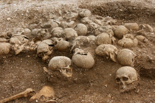
In 2010, the list of the most terrible archaeological excavations was supplemented by scientists who carried out work in Dorset. The group hoped to find household equipment of their ancestors, their clothing, and working tools in order to supplement historical data about their life. But what they stumbled upon horrified them. Scientists have discovered the remains of human bodies, but without heads. The skulls were located not far from the grave. Having carefully studied them, archaeologists came to the conclusion that these were the remains of Vikings. However, there were not enough skulls. Therefore, we can conclude that the punitive forces took several heads as a trophy. The burial of 54 Vikings took place in the 8th-9th century.
Unknown creature

Amateur scientists taking a walk around National Park in New Zealand, we came across a karst cave. The young archaeologists decided to visit it. Walking along the corridors of the cave, the group saw a skeleton that was well preserved, but presented an eerie sight. The rather large body had rough skin, a beak, and huge claws. I don’t understand at all where this monster came from; the guys urgently left the cave. Further research showed that these were the remains of an ancient moa bird. Some scientists are sure that she still lives on the planet, just hiding from people.
Crystal Skull

Archaeologist Frederick Mitchell Hedges made a stunning discovery while walking through the jungles of Belize. They found a skull made of rock crystal. The weight of the find increased by 5 kg. Tribes living nearby claim that the skull is a Mayan heritage. There are 13 of them scattered around the world, and whoever collects the entire collection will gain access to the secrets of the universe. Whether this is true or not is unknown, but the mystery of the skull has not been solved to this day. Surprisingly, it is made using technology that contradicts known to mankind chemical and physical laws.