I often come across interesting views of the Earth from space. It’s somehow not interesting to publish them separately, but by putting some effort and putting them together, you can get a very informative note. In fact, the photographs were collected and remembered for at least two years. So, I think this is one of the most detailed materials on this topic. All images are clickable.
Earthrise(Earthrise) is the title of a photograph of our planet taken by astronaut William Anders on December 24, 1968, during the flight of the Apollo 8 spacecraft around the Moon. Perhaps the most famous view of the Earth from space.

Blue ball(Blue Marble) is a photograph of planet Earth taken on December 7, 1972 by the crew of the Apollo 17 spacecraft from a distance of approximately 29 thousand kilometers from the Earth’s surface.
In 2002, NASA stitched together from a huge number of images new version famous photograph.


This is currently available.

Distant Earth and Moon. The photograph was taken on September 18, 1977 by Voyager 1 from a distance of 11.5 million kilometers.

And this is a composite image collected from photographs of the Galileo spacecraft.

The image is a composite of 165 photographs taken by the Cassini spacecraft on September 15, 2006. Our planet is a point on the top right in the void between the dense rings and the penultimate ring.

Pale blue dot(Pale Blue Dot). Earth as seen by Voyager 1 from a record distance of 5.9 billion kilometers. (Dot on the right side of the top line)

Niger River, Republic of Mali.

The sun rises over the Pacific Ocean.

The image is a composite of four photographs taken by ESA's OSIRIS space camera.

No matter how usual it is to see the northern lights from below, from Earth, from space they look much more spectacular.

Russian space station Mir Above the Earth. Photo taken from the Atlantis shuttle in June 1995.

The photo shows the shadow of the moon over Cyprus and Turkey. This is complete solar eclipse happened on March 29, 2006.

NASA astronaut Robert L. Stewart soars above the clouds. Photo taken from the Challenger shuttle in February 1984.


Planet earth reflected in the helmet of astronaut Clayton C. Anderson on August 15, 2007.
And earlier I showed you the most beautiful and stunning ones.
The globe in our imagination seems to be a gigantic system that functions according to its own rules. Everything in our world is relative. If we consider the Earth as a planet solar system, it will not be so big in size relative to others..
Our planet is very beautiful, no matter how you look at it. The earth's landscapes are pleasing to the eye, the fauna and flora are delightful. Images taken on orbiting satellites or the ISS open up even more opportunities for us to see the enchanting beauty of the Earth, which should be preserved and protected.


Photo of the Earth from Space in high quality
The photographs of the globe that are published in this section of our website are authentic and taken by astronauts of the International Space Station. Very few people get the chance to observe our planet from space. So we thank the European Space Agency, NASA and the astronauts for the footage they make available for public viewing. Previously, something like this could only be seen in Hollywood films, but there these photographs were not always real.


Images of the Earth from Space are of interest not only to military personnel, meteorologists, and surveyors. Everyone wants to look at the giant ball from afar and find their approximate location on it. Looking at photographs like this high quality, you are amazed by the beauty and fragility of our planet. How great is the diversity of landscapes and climatic conditions... In the photographs you can see coastline continents, see large sizes atmospheric vortices, glaciers in Antarctica and the Arctic, deserts and mountains, cities and megalopolises.


The photos of the Earth at night are incredibly beautiful. The darkened side of the planet sparkles with many lights. From them we can draw conclusions about the size of individual cities and the geography of human settlement.
Real photos of the Earth from Space
When flying on an airplane and looking out the window, you can see the sky, clouds, and earthly landscapes. People who jump from a plane with a parachute are not only driven by the feeling of adrenaline, but also by the desire to see the earth's surface from a bird's eye view. The Earth looks completely different from Space. The portal site selects for visitors only real, high-quality photos that change our imagination about the Universe. The feelings we get when viewing them cannot be compared with anything on earth. The view of the planet from the mysterious Space cannot be expressed in words. Only people who have conquered outer space - our cosmonauts - can describe it. We are proud that it was our compatriot, Yuri Gagarin, who became the first space traveler. It is thanks to the achievements of science, which allowed man to overcome the force of gravity, that now everyone can see what is impossible to see from Earth.


Thinking about the meaning of life, the arrangement of the world, what awaits us in a decade, it is impossible to find an answer to these questions. In photos taken from spaceships, the Earth appears round and small. Actually this is not true. It’s just that the distance from which photography is taken is gigantic.

The most interesting thing, of course, would be not to watch a video or photo, but to see this wonderful planet called Earth live from Space. Perhaps that time is just around the corner. Some of us will overcome the force of gravity, see the beauty of the planet from afar and take more than one beautiful photo. He will be incredibly proud and happy to receive a ticket to Space!
The birth of astrophotography is considered to be October 24, 1946. On this day, the American V-2 automatic rocket took the first photograph of the Earth from a suborbital altitude, about 105 km.
A series of photographs of the Earth were taken with a 35 mm film camera on black and white film; the quality of the image, by modern standards, was not the best.
The first astrophotography of the Earth from an altitude of 105 km.
In August 1959, the unmanned spacecraft Explorer 6 launched from Cape Canaveral, Florida, USA. It was equipped with photo elements that conveyed the picture earth's surface and atmosphere. It took almost 40 minutes to transmit the first photograph to Earth. The first orbital astrophotography captured a section of the earth's surface illuminated by the sun - it was Mexico. Explorer 6 ship rushed at a speed of over 32 thousand kilometers per hour, at an altitude of 28 thousand kilometers. This image is considered the first satellite photograph of the Earth from space.

The first satellite photograph of the Earth, from an altitude of about 28,000 km.
The first video of the Earth filmed in orbit
During a 25-hour space flight on August 6-7, 1961, Soviet cosmonaut German Stepanovich Titov made the first manual photography and video recording of the Earth from space.The filming was carried out with a Konvas film camera. In the book of memoirs “My Blue Planet” (1977) G.S. Titov wrote that the shooting was successful:
I tried to remember everything that I was taught in film training classes in order to film the view of our planet from the height of space flight, to film it so that people could look at their home - the planet from the outside. And the filmmaking practice really came in handy for me. Having prepared the Konvas camera, I decided to determine the exposure. On Earth, I often did this by eye, but here I didn’t take the risk, since an error in exposure could be costly. This is not filming a fishing scene. I took out a photo exposure meter, and... it turned out that I could easily put it back. The arrow of the sensitive element fell off under the influence of overloads and vibrations and, under conditions of weightlessness, occupied completely arbitrary positions. The first introductory note, as we say, has appeared. There was nothing left to do but estimate the illumination by eye and select the aperture. And then I remembered the saying “every cloud has a silver lining.” Some of the films I produced on Earth were, frankly speaking, not of the best quality. But practice “by eye” helped me out, and the film from space turned out to be successful.

A still from German Titov's photography of the Earth.
The Blue Marble “blue marble” is one of the most famous photos of planet earth, taken on December 7, 1972 by astronauts of the Apollo 17 spacecraft from a distance of about 29 thousand km. The photo shows the illuminated Earth while the Sun was behind the astronauts. This astrophotography has been used in many films to depict the Earth from space.

Far reaches of the solar system
Pale Blue Dot is an astrophotography of planet Earth that is impressive in its scale. This image, taken by the Voyager 1 probe from a distance of 5.9 billion km, shows the Earth against the backdrop of space. The very idea of taking a picture was proposed by astronomer and science popularizer Carl Sagan. Voyager had already completed its mission and was flying towards the boundaries of the heliosphere when, in February 1990, NASA commanded the device to turn around and take photographs of the planets of our star system. One of the images taken between February 14 and June 6, 1990, was an image of our planet, represented by a "pale blue dot" in a grainy image, is the most distant image of the Earth.

The small dot in the middle of the brownish stripe on the right is the Earth from a distance of 6 billion kilometers.
"Earthrise" - Earth photography, most likely taken by astronaut William Anders during his flyby of the Moon spaceship"Apollo 8". One of the most popular photographs of the Earth from space. The photo was taken on December 24, 1968.

"Earthrise" is one of the most famous photographs of our planet.
In February 2014, the Curiosity rover took pictures of the Earth from the surface of Mars. The picture was taken on a Martian night. Our planet was visible at this time, even without approaching. Also, the cameras of the device managed to take a picture of the Moon. It looked like a tiny bright speck next to the Earth. Let us remind you that these are not the first images from the surface of Mars. Previously, filming was carried out:
- NASA Spirit Mars rover 2004
- Mars Global Surveyor 2003
- Mars Reconnaissance Orbiter 2007

An image of the Earth from the surface of the “red” planet taken by the Curiosity rover
Likes( 1 ) Dislikes( 0 )
(Total 29 photos)

1. Go Discovery! On October 23, 2007 at 11:40 am, I went into space for the first time on the Discovery shuttle. He is wonderful... it's a pity that this is his last flight. I'm looking forward to boarding the ship when it arrives at the station in November.

2. Earthly radiance. The space station is in the blue terrestrial glow that appears when the rising sun pierces our planet's thin atmosphere, bathing the station in blue light. I will never forget this place... a view like this makes my soul sing and my heart wants to fly.

3. NASA astronaut Douglas H. Wheelock.

4. Juan de Nova Island in the Mozambique Channel between Madagascar and Africa. The amazing colors of these places can compete with the views of the Caribbean Sea.

5. Northern lights in the distance in one of beautiful nights over Europe. The Strait of Dover is clearly visible in the photo, as is Paris, the city of lights. Light fog over western England, particularly London. How incredible it is to see the lights of cities and towns against the backdrop of deep space. I will miss this view of our wonderful world.

6. “Fly me to the Moon...let me dance among the Stars...” (Take me to the Moon, let's dance among the stars). I hope we never lose our sense of wonder. A passion for exploration and discovery is a great legacy to leave to your children. I hope someday we'll set our sails and set off on a journey. Someday this wonderful day will come...

7. Of all the places on our magnificent planet, few can compete in beauty and richness of colors with. This photo shows our ship “Progress-37” against the backdrop of the Bahamas. How beautiful our world is!

8. At a speed of 28,163 km/h (8 km per second)... we orbit the Earth, making one revolution every 90 minutes, and seeing sunsets and sunrises every 45 minutes. So half of our journey takes place in pitch darkness. To work, we simply need flashlights on our helmets. In this photo I am preparing the handle of one device... "M3 Ammonia Connector".

9. Every time I look out the window and see our beautiful planet, my soul sings! I see blue skies, white clouds and a bright blessed day.

10. Another spectacular sunset. In Earth's orbit, we see 16 such sunsets every day, and each of them is truly valuable. This beautiful thin blue line is what makes our planet stand out from so many others. It's cold in space, and the Earth is an island of life in the vast dark sea of space.

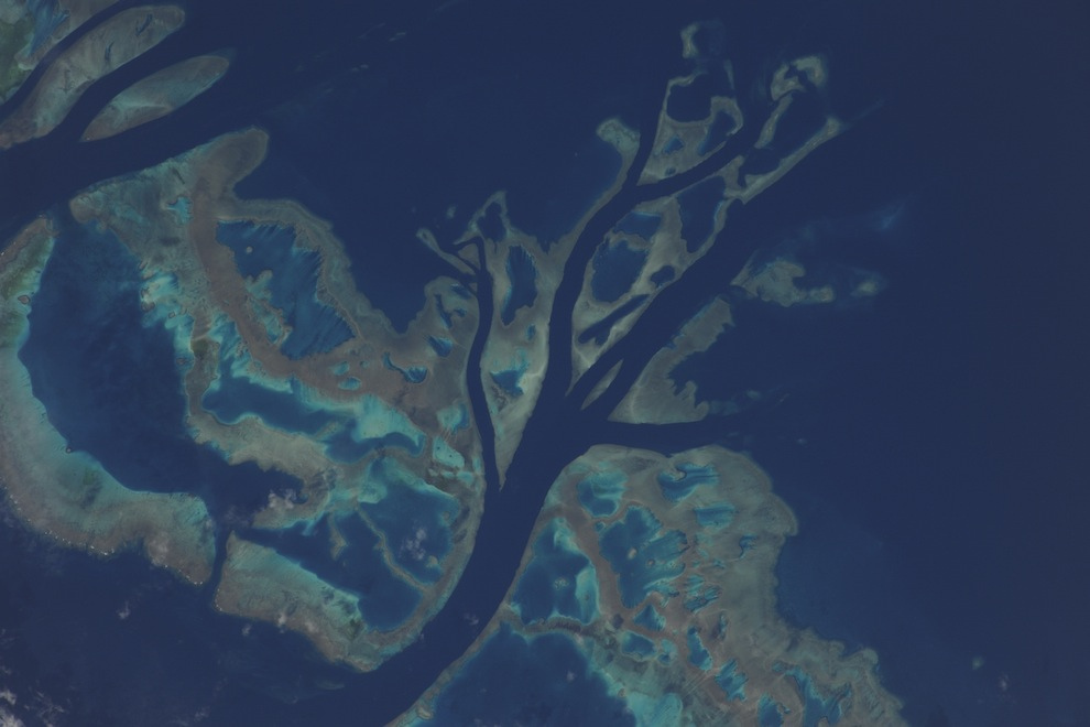
11. A beautiful atoll in the Pacific Ocean, photographed with a 400mm lens. Approximately 1930 km south of Honolulu.

12. Beautiful reflection sunlight in the eastern part Mediterranean Sea. There are no borders visible from space... From there you can only see breathtaking views, such as the view of this island of Cyprus.

13. Above the center Atlantic Ocean, before another amazing sunset. Below, the spirals of Hurricane Earl are visible in the rays of the setting sun. Interesting look at vital energy our sun. The sun's rays on the port side of the station and on Hurricane Earl... these two objects are collecting the last bits of energy before plunging into darkness.

14. A little further to the east we saw the sacred monolith of Uluru, better known as Ayers Rock. I've never had the opportunity to visit Australia, but one day I hope to stand next to this natural wonder.

15. Morning over the Andes in South America. I don’t know for sure the name of this peak, but I was simply amazed by its magic, the peaks reaching out to the sun and winds.

16. Over the Sahara Desert, approaching ancient lands and thousands of years of history. The Nile River flows through Egypt past the Pyramids of Giza in Cairo. Further, the Red Sea, the Sinai Peninsula, the Dead Sea, the Jordan River, as well as the island of Cyprus in the Mediterranean Sea and Greece on the horizon.

17. Night view of the Nile River, stretching like a snake through Egypt to the Mediterranean Sea, and Cairo, located in the river delta. What a contrast between the dark lifeless desert northern Africa and the Nile River, on the banks of which life is in full swing. The Mediterranean Sea is visible in the distance in this photo taken on a beautiful autumn evening.

18. Our unmanned 'Progress 39P' is approaching the ISS for refueling. It's full of food, fuel, spare parts and everything we need for our station. Inside was a real gift - fresh fruits and vegetables. What a miracle after three months of tube feeding!


20. Soyuz 23C Olympus module docked on the nadir side. When our work here is finished, we will return home to Earth. I thought you might be interested in seeing this spectacle through the Dome. We fly over the snow-capped peaks of the Caucasus. Rising Sun reflected from the Caspian Sea.
21. A flash of color, movement and life on our canvas amazing world. This is part of the Great Barrier Reef off the east coast of Australia, captured through a 1200mm lens. I think even the great impressionists would have been amazed by this natural painting.

22. All the beauty of Italy on a clear summer evening. You can see many beautiful islands decorating the coast - Capri, Sicily and Malta. Naples and Mount Vesuvius stand out along the coast.

23. At the southern end South America lies the pearl of Patagonia. The stunning beauty of the rugged mountains, massive glaciers, fjords and open sea combines in amazing harmony. I dreamed about this place. I wonder what it would be like to breathe the air there. Real magic!

24. The “dome” on the nadir side of the station gives a panoramic view of our beautiful planet. Fedor took this photo from the window of the Russian docking bay. In this photo I'm sitting in the canopy getting my camera ready for our evening flight over Hurricane Earl.

27. Clear Starlight Night over the eastern Mediterranean Sea. Ancient lands from thousand years of history stretch from Athens to Cairo. Historical lands, fairytale cities and tempting islands... Athens - Crete - Rhodes - Izmir - Ankara - Cyprus - Damascus - Beirut - Haifa - Amman - Tel Aviv - Jerusalem - Cairo - they all turned into tiny lights on this cool November night. These places seem to emanate grace and tranquility.

28. At this time of year you can fully enjoy the beauty of polar mesospheric clouds. Using our high light angle we were able to capture a thin layer of noctilucent clouds at sunset.

29. Shannon, me and Fedor in our Falcon suits in the MRM-1 module. We boarded the Olympus capsule to pressurize and check for leaks on our suits. All systems are running, the countdown has begun.
Remember the movie “Men in Black”, where Agent Kay looked through an orbital camera at his beloved watering flowers in the courtyard? The opportunity to see what our Earth looks like from a satellite in real time attracts people from all over the world. Today we will tell you - and show you! - the best fruits modern technologies on Earth observation.
Attention! If you see a dark screen, it means the cameras are in the shadows. Screensaver or gray screen - no signal.
Usually we only get static satellite maps, frozen in time - details have not been updated for years, and an eternal summer day reigns outside. Isn't it interesting to see how beautiful the Earth is from a satellite online in winter or at night? In addition, the quality of images of some regions of Russia and the CIS leaves much to be desired. But now all this can be solved in one fell swoop - thanks to , Earth online from a satellite in real time is no longer science fiction. Right on this page you can join thousands of people who are now observing the planet.
At an altitude of 400 kilometers above the planet, where the station is permanently located, NASA installed one developed by private companies. The astronauts themselves or at the commands of the Mission Control Center direct the cameras from which data is transmitted. Thanks to manual control, we can see what the Earth looks like from a satellite online from all sides - its atmosphere, mountains, cities and oceans. And the mobility of the station allows you to view half of the globe in an hour.
How does the broadcast happen?
Thanks to the fact that the cameras are located at the International Station, even minor details are visible to us, which are commented on by scientists, cosmonauts and professional journalists. However, our Earth is visible online from a satellite in real time thanks to the work of a whole complex of people and machines - in addition to the already mentioned astronauts and the Control Center, the process involves satellite communication transmission technologies, solar power batteries and technical specialists involved in data translation and decoding. Accordingly, the broadcast has its own nuances - knowing them will help you see more and better understand what is happening on the screen.
Our observation point, the orbital station, moves at enormous speed - almost 28 thousand kilometers per hour, and circles the Earth in 90-92 minutes. Half of this time, 45 minutes, the station hangs on the night side. And although on approach the solar panels of the cameras can be powered by sunset light, in the depths the electricity disappears - therefore it is not always available from the satellite. At such moments, the broadcast screen turns gray; Just wait a little and you will be watching the sunrise with the astronauts.
In order to find best time for observations, you will need our special map of the Earth from a satellite - it marks not only the time of passage of the space station, but also its exact position. This way you can find out when to see your city from space heights, or find a station in the sky with binoculars or a telescope!
We have already mentioned that astronauts and ground control can change the aiming of cameras - they provide not only entertainment, but also scientific function. At such moments, planet Earth is not accessible from a satellite in real time - a black or blue screensaver appears on the screen, or already captured moments are repeated. If there are no interruptions in satellite communications, the station is on the day side of the planet, and the background suddenly changes, then the cameras are filming areas inaccessible to the public due to international treaties. Secret objects and forbidden territories are closed on static maps, skillfully hidden by photo editors or simply erased. All that remains is to wait for the moment when the situation in the world relaxes, and there will be no secrets from ordinary citizens.
Hidden Features
But don't be upset if the camera isn't working right now! When planet Earth cannot be shown online from satellite, astronauts and NASA find other entertainment for viewers. You will see life inside the International Space Station, astronauts in zero gravity, who talk about their work and what kind of satellite view of the Earth will be shown next. They even allow you to look into the impressively large Mission Control Center. The only negative is that even the speech of Russian cosmonauts is translated into English so that it can be understood by the American employees who manage the Center. Turn off translation to this moment impossible. Also, don’t be surprised by the silence - comments are not always appropriate, and there is no constant sound accompaniment yet.
For those who predict the route of cameras using the capabilities provided by a real-time satellite map of the Earth, we have advice - check the date and time settings on your computer. The server that updates the map uses the given International Station motion formula and the time zone of your IP address to predict the position of the orbital cameras. What does the Earth look like from a satellite? online map judges solely by device time. If your clock is slow or fast relative to the time zone, the station will move east or west accordingly. The use of proxy servers and anonymizers will also affect the results.
Live broadcast of NASA TV channel
You are a participant in a scientific program
Surely you have noticed that the quality of the picture of the planet Earth from space and a live broadcast from a satellite often changes - the image is covered with squares or lags behind the audio track. In most cases, it is enough to check the speed of your Internet connection, disable other videos and programs for downloading files, or click on the HD button in the broadcast window. However, even if there are interruptions, it is worth remembering that the planet can only be seen alive thanks to a large-scale scientific experiment.
Yes, yes - the video on this page is transmitted for a reason. The cameras installed on the International Space Station are part of the High Definition Earth Viewing program (from English: view of the Earth from a satellite in high resolution), which is still being improved and developed. The cameras are installed by astronauts in conditions isolated from cold and dust, but they are exposed to harsh radiation from the outside. Scientists are experimenting with the difficulties of seamless data transmission in space, ensuring that a map of the Earth from a satellite good quality existed not only motionless, but also living, dynamic. The results will help improve existing channels and create new ones - even in Mars orbit in the foreseeable future.
So let's stay in touch - new things appear in the world of space every day!