RUSSIAN LANDS AND PRINCIPALITIES in the XII - early XIII V. Fragmentation of Rus'.
The fight against the Polovtsians in the second half of the 12th century.
Since the 30s. XII century Rus' entered a new period in its history - a period of political (state) fragmentation, which was a natural stage in the development of all large European states.
After the death of Mstislav the Great in 1132, a time came that the Russian chronicler described with the words: “the whole Russian land was in rage.” Among the descendants of Yaroslav the Wise and Vladimir Monomakh, a struggle began for possession of the Kyiv throne. And although the Grand Duke of Kiev lost his former power in Rus', he was nominally considered the “oldest” Russian prince, and many wanted to receive such an honorary title. The struggle for Kyiv was extremely fierce. From 1132 to 1169, the grand-ducal throne changed hands 14 times. In 1169, squads of 11 Russian princes and Polovtsian khans took part in the storming and destruction of Kyiv.
By the middle of the 12th century. Rus' broke up into 15 independent principalities. Half a century later there were already 50 of them. One of the reasons for this state of statehood
(Pechenegs, Polovtsians) to the southern Russian lands for centuries slowed down their overall progress, caused the decline of Kyiv as the center of united Rus', reduced the importance of the trade route “from the Varangians to the Greeks,” and led to an outflow of the population to quieter regions of North-Eastern Rus'.
in Rus' there were princely divisions of lands between the Rurikovichs, their endless internecine wars and new redistributions of land.
But behind the princely strife there were deeper reasons that led Rus' to a period of fragmentation. Within a single Old Russian state Over the course of three centuries, independent economic regions emerged, cities grew, large patrimonial farms and church estates were formed. Next to the local prince, powerful feudal groups of patrimonial boyars with their vassals formed; A wealthy elite of cities grew up, which, in addition to princes, boyars and clergy, included merchants and owners of large craft workshops. Now they all wanted to have power not in distant Kyiv, but their own, local, which would know better and more decisively defend their interests. In addition, the raids of nomads
With the collapse of Rus' into independent principalities, the once unified and powerful defense of the country was fragmented into separate lands. Militarily and politically, Rus' became much weaker, which the Polovtsians took advantage of. Their raids on Rus' became especially frequent in the 70-80s. XII century This forced the princes to periodically combine their forces to repel the enemy. So, in 1184 the united Russian army, led by prince of Kyiv Svyatoslav, inflicted a major defeat on the steppe inhabitants of Khan Kobyak.
In 1185, Prince of Novgorod-Seversk Igor Svyatoslavich also opposed the Polovtsians. He was joined by squads from Trubchevsk, Putivl, Rylsk and a detachment of the Chernigov prince. Moving south, the united Russian army on the Syurlia River met the advanced forces of Khan Konchak and defeated them. But the next day the main forces of the Polovtsians surrounded Igor’s army. On May 12, in a fierce battle near the Kayala River, the Russian squads were defeated. Prince Igor was captured, but he managed to escape. The campaign of the Novgorod-Seversk prince is reflected in a wonderful monument ancient Russian literature- “The Tale of Igor’s Campaign.” The author of the Lay calls on the Russian princes to stop strife and sets them as examples of Yaroslav the Wise and Vladimir Monomakh, under whom Rus' was a unified state and defeated its enemies.
But the political collapse of the Old Russian state was never complete; it did not lead to the decline of Rus'. New cities were built, new lands were developed, large centers of craft, trade and culture grew, and the forces that contributed to the unity of the country were preserved. In all the principalities and lands lived people who made up a single ancient Russian nationality. They spoke the same language, professed the same religion, and continued to live according to laws, the basis of which were the norms of Russian Truth. In addition to all this, the idea of uniting all forces to combat external danger was constantly preserved in the Russian lands.
In the last millennium, the Rus Empire in the already breakaway Western Europe began to be called “ Great Tartary " It was and still remains the largest power in the World, which enemies are still trying to crush into small pieces - appanage principalities that would be easier to conquer and destroy the population...
« Russia is a unique country, unique in every way. Just take the name of the country and... a whole layer of information will emerge, about which the majority of Russian residents do not have the slightest idea. The name of the country - Russia, arose from another word - Russey, which, in turn, was formed from the name Russey. Russenia was the name given to the part of the ancient Slavic-Aryan Empire that lay west of the Ripean (Ural) mountains. The lands east of the Urals to the Pacific Ocean and further, from Lukomorye ( Russian North) to Central India, bore the name Land of the Holy Race. Foreigners called this country differently. One of the last foreign names known in Europe until the end of the eighteenth century was Great Tartaria is the largest country in the world, as described in the first edition of the Encyclopædia Britannica in 1771. Those interested can see this for themselves by looking at this edition of the encyclopedia...”
* About Essence, Mind and much more... - official website amazing person, Russian scientist, healer, writer - academician Nikolai Levashov
V.V. Putin declassified the archives of Tartaria [Past of Rus']

At school they tell us that we, Russian people, have only one thousand years of our wretched past. It’s just pathetic, because before the arrival of Christianity in Rus', we were all supposedly wild animals, but the church turned us into people. However, many facts contradict these fictions. For example, in the Encyclopedia Britannica of 1771, our Motherland is described as the largest and most developed state on Earth called Great Tartaria. There are many documents and maps that confirm this. Some of them are located in Russian Geographical Society, where President Vladimir Putin visited on January 15, 2013. And there he was shown these documents and maps, as evidenced by the video recordings of this visit. And other artifacts, such as the Chandar Plate, irrefutably testify to us that the level of development of the civilization of our ancestors was incomparably higher than they are trying to convince us of. This level is higher than even the current level of development of our civilization.
* On the website "" you will find detailed story about artifacts and evidence ancient history humanity. -
The past of Rus'. Great Tartaria - Rus Empire
The past of the Slavic-Aryans is the past of our earthly civilization. There is already a lot of truthful information! You just need to look for it and popularize it as widely as possible among the Rus and all other peoples who want to know the truth...

The film "Great Tartary - Empire of the Rus" is a short story about the great past of our Motherland. Several thousand years ago, the Rus Empire occupied almost all habitable lands on the planet: Eurasia, North America, North Africa... There were very few people of the yellow, red and black races on Earth, and they lived compactly in areas with their usual climatic conditions. But over time, our powerful enemies found ways to gradually push back and destroy the Slavs. In the last millennium, the Rus Empire in the already breakaway Western Europe began to be called “Great Tartary”. It was and still remains the largest power in the World, which its enemies are still trying to crush into small pieces - appanage principalities that would be easier to conquer and destroy the population...
The film is based on unique works Svetlana and Nikolai Levashov.
In the film you can get answers to the following questions:
- Who were the URs really, and what influence did they have with their cult "URa (Vedic worldview) on the system of moral and spiritual values of the Slavs? And why do some of our neighbors still call the Rus "UR-Russ"?
- How did the castes of Magi, artisans, grain growers, cattle breeders, and the tribes of Scots, Polyans, Drevlyans appear...
- What is common between the content of the Slavic-Aryan Vedas and the book of Veles?
- What do we know about Atlantis from ancient written sources of the Slavs and Aryans?
- Why did the war begin between the Great Russia (Rus) and Arimia ( ancient china- the country of the “Great Dragon”) more than 7520 years ago? And how did the symbol of this victory - St. George the Victorious, slaying the Serpent (the image of the enemy, Arimia) - become a “Christian saint”?
- How did the largest country in the World - Great Tartary - disappear from geographical maps in the 18th century? And why was total falsification possible? World history and the history of Russia in particular?
I was looking for cards Russia XVII century and XVIII century. I'm so interested the former borders of our state that I decided to find maps of Russia from other centuries. Although, of course, all this was covered in history at school, but now, after years, it is perceived somewhat differently. I offer you a short journey into the depths of centuries along the borders of the Russian state.
Borders of the Old Russian state in the 9th – 11th centuries. The Old Russian state was formed in 862.
Map of Ancient Rus' during the period feudal fragmentation V XII beginning XIII century, when the ancient Russian lands were tormented on the one hand by civil strife between princes, and on the other hand by raids of nomads. Each principality had its own borders.

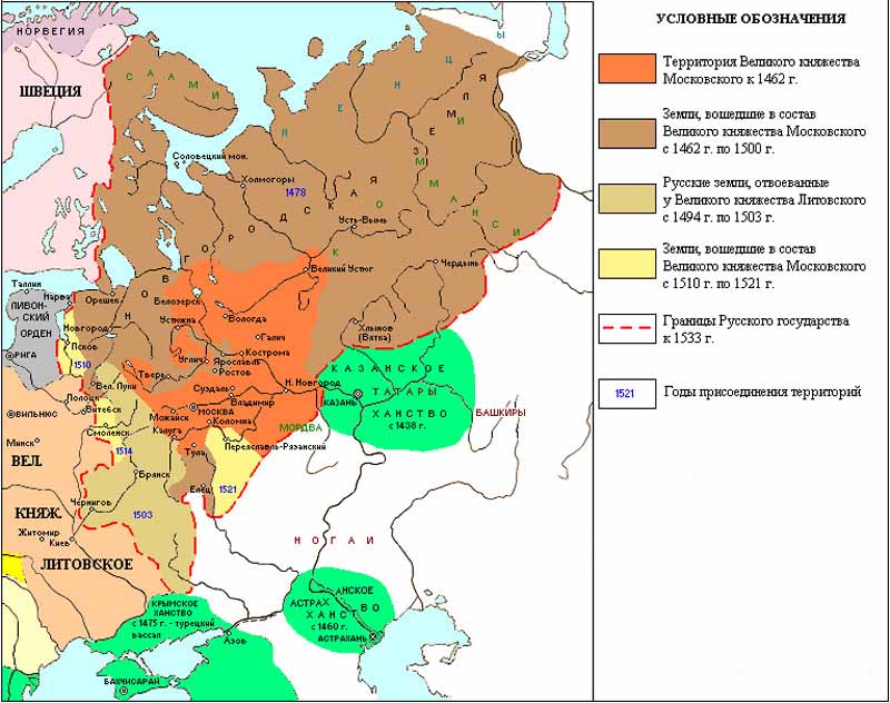
Map of Rus' in the 14th century during the period of the Tatar-Mongol yoke, when part of the lands of northeastern Rus' united around the Moscow principality, and part of the western Russian lands became part of Principality of Lithuania. But each principality that joined the Moscow principality retains its own borders.

IN XV-XVI centuries a single border of the Russian state was formed again.
At the end of the 16th century the borders Russian state moving towards the Caspian Sea and beyond. In the 17th century they reach the Pacific Ocean, and in the west Russia regains the lands of Kievan Rus.

In the XVIII – 19th centuries The Russian Empire owns the largest territory in its entire history. Its borders reached America, the Alaska Peninsula was discovered by a Russian expedition in 1732 and was Russian territory until it was sold to the United States in 1867. The territory of Russia expanded to the south - to Central Asia, Caucasus and Crimea. Also, the border moved west to the limits of the Old Russian state. And in the north-west the composition Russian Empire Finland entered.

On the map of the Russian Empire at the beginning of the 20th century, the borders on the islands change Far East. Since 1855, Sakhalin Island has officially been a joint possession of Russia and Japan. In 1875, under a treaty, Russia transferred the Kuril Islands to Japan in exchange for undivided ownership of the island of Sakhalin. And after Russia's defeat in Russo-Japanese War(1904 - 1905) the southern part of Sakhalin went to Japan.

20th century, borders of the USSR, which includes 15 union republics: RSFSR, Lithuania, Latvia, Estonia, Belarus, Moldova, Ukraine, Georgia, Armenia, Azerbaijan, Kazakhstan, Turkmenistan, Uzbekistan, Tajikistan, Kyrgyzstan. After the Second World War, the entire territory of the island was included in the USSR. Sakhalin and all the Kuril Islands.

Map modern Russia. End XX – beginning of XXI centuries after the collapse of the USSR, each republic was on its own, all 15 republics became sovereign states with their own borders.

This is how they have changed over the centuries borders of our state .
Did you like the article? Tell your friends about this!!!
Reprinting site materials, including photographs, without the permission of the site author and without a link to articles is prohibited.
The first attempts at administrative-territorial division of our lands can be considered the existence of principality lands during the times of Kievan Rus.
In the 9th-12th centuries the territory modern Ukraine was divided into Chernigov-Seversk, Pereyaslav, Volyn and Galician lands. All of them were part of the Kyiv state.
WITH mid-XII century, the process of decline of the Kyiv state begins. Heir to political and cultural traditions The Principality of Galicia-Volyn becomes Kievan Rus. In the XIII - first half of the XIV centuries. The Galician-Volyn principality included a significant part of the Ukrainian ethnic territory.
With the death of Yuri II Boleslav in 1340, the decline of the Galician-Volyn state began. In the second half of the 14th century. Most of the Ukrainian lands were captured by foreign powers. For example, Lithuania conquered part of Volyn, Brest and Dorogochinsk lands, Chernigovo-Severshchina, Kyiv and Podolsk lands.
In 1387, as a result of a long-term war between Poland, Hungary and Lithuania, Galicia was annexed to the Kingdom of Poland.
At the beginning In the 1440s, the Volyn and Kiev principalities were restored. However, in the second half of the 15th century, after the death of Svidrigail and Semyon Olelkovich, they were finally liquidated and transformed into Lithuanian provinces. In their place, the Kiev, Bratslav and Volyn voivodships were created, which were governed by grand-ducal governors - voivodes.
After the conclusion of the Union of Lublin between Poland and Lithuania in 1569, all Ukrainian lands, with the exception of Brest and Dorogochinsk, Transcarpathia, Bukovina and Chernihiv region, came under the direct authority of the Kingdom of Poland.
Portolan of the Black Sea basin. By Agnes Battista, 1550. On the map - Rus', Tartary and Muscovy_2.jpg)
Starting in 1608, for about 300 years, Ukraine appeared on political map world sporadically.
In particular, in the years 1608-1615, the borders of the independent Cossack state at that time were not stable, and after some time it was completely transferred to Muscovy. In 1618, Chernigovo-Siverschyna came under Polish rule.
At the beginning of the 17th century. The territory of present-day Ukraine was divided between Poland and Russia. Over the next 35 years, Poland's territory continued to expand, but the division between the two states still remained.

"Typus Generalis Vkraine" (General description of Ukraine). Author - Johann Jansonius, 1649

Poland, Lithuania and Ukraine as part of the Polish-Lithuanian Commonwealth. Author - Carlo Alard, 1670

"Vkraine ou Pays des Cosaques" (Ukraine is the state of the Cossacks). Author - Guillaume Sanson, 1674

"Ukraine grand pays de la Russie Rouge avec une partie de la Pologne, Moscovie..." (Big country - Red Rus', bordering Poland, Russia, Wallachia...). Author - Pierre van Der, 1710

"Amplissima Ucraniae Regio..." (Ukraine and regions). Author - Tobias Conrad Lotter, 1770

During Russian-Turkish wars XVIII century The lands of the "Wild Field" were populated. It was then that it was founded largest cities modern Southern Ukraine: Elizavetgrad (Kirovograd, 1775), Ekaterinoslav (Dnepropetrovsk, 1776), Kherson (1778), Nikolaev (1789) and Odessa (1794).
As a result of the second and third partitions of Poland in 1793-1795. Right Bank Ukraine and Volyn were annexed to Russia. Galicia, Bukovina and Transcarpathia remained part of Austria-Hungary.
And in 1812, Bessarabia (Moldova and Burjak) was annexed to Russia.
XX century was marked by the appearance of Ukraine on the political map of the world.
Historical map of the Ukrainian State during the time of Hetman Pavlo Skoropadsky, October 1918

The limits of Ukraine, which were declared by the UPR at the Paris Peace Conference. 1919

1923 - the eastern part of Ukraine became part of Soviet Union, and in 1939 the western territories joined it.
"Modern division Eastern Slavs by languages." Kudryashov's Atlas as part of the "Russian Historical Atlas", 1928

Map of the Ukrainian SSR, 1931

Map of Ukraine between the two world wars

Map of the USSR, 1940. Pocket Atlas of the USSR, 11th ed.

In 1954, in accordance with the decree of the Presidium of the Supreme Soviet, the USSR became part of the Ukrainian SSR.
What does it look like modern map Ukraine:
 You can also view the infographic of changes in the borders of Ukraine in the video:
They changed their appearance and borders more than once. It all started with Kievan Rus.
First information about the construction maps of ancient Rus' reach us from the depths of pre-Petrine times. Even large landowners of the 14th century sought to outline, at least schematically, their property on paper. The mention of the “Drawing of Moscow lands” as the first Russian geographical map single country, dates back to 1497. In 1525, Pavel Joviy Novokomsky, bishop and geographer, based on data received from the Russian ambassador Dmitry Gerasimov, compiled a book for residents Western Europe. It contained a map of Muscovy and described the geography, customs and life of the inhabitants of Rus'. In addition, in this book, for the first time, a hypothesis was put forward about the existence of a Northeast Passage, along which ships could travel from the northern outskirts of Rus' to China. Almost 30 years later, the Italian cartographer Battista Agnese placed in his atlas a map called “Muscovy. Drawing compiled according to information from Ambassador Demetrius."

Map of ancient Rus' Drawing of Moscow lands 1497

Anthony Weed

Herberstein
In 1542, the Lithuanian cartographer Anthony Vid created a “map of Muscovy” based on information received from Lyatsky. Two years later, it was published as part of Münster’s Cosmography. This map for the first time depicted the territory from the Caspian Sea in the south to the borders of Finland in the north, and from Kyiv in the west to the Ob River in the east. In parallel with Münster, the Austrian diplomat Baron Sigismund von Herberstein worked on his version of the map of Muscovy. His work was published in 1546 by Hirschvogel's publishing house. Despite the fact that Herberstein’s map looks more schematic than Munster’s, it surprisingly accurately depicts the Urals and the forests of southern Rus'.

Large drawing of Ivan the Terrible
During his life, Ivan IV the Terrible collected about 250 maps in his archives, one of which was the “Big Drawing”. Compiled by order of the king in the second half of the sixteenth century, this map went through many editions and revisions, but was subsequently lost. Nevertheless, the “Book of the Big Drawing” has been preserved - detailed description lost card. It includes detailed information about the nature, life and economy of the peoples inhabiting Russia, talks about the main rivers and seas, indicates cities and the distances between them, including border fortresses. In addition, under Ivan IV, in 1556, the first manual for land surveying was compiled, which was called “The Book Called Geometry or Land Surveying by Radix and Compass...”.

“Map of Moscow Lands” is considered the first printed map of Russia; its publication date is considered to be January 26, 1525. However, for the most part, maps of ancient Rus' in the 16th and 17th centuries remained handwritten and existed in only one version. Due to this, frequent fires Time of Troubles, the negligence of the keepers, who did not see the value of the old drawings, did their job and most of the maps of that time are lost to us forever.